Italiano
 Deutsch
Signal du Lamet 3500 m

CicloAlpinism itinerary, technical descent also off trail, about 300 m of non-cyclable descent.
The tam tam runs fast among Ciclodisagio friends, and a 3500 summit even outside VdA is a must-do. As always, however, I personalize the Itinerary by putting in a little something of my own.
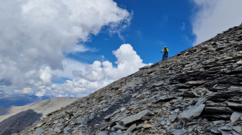
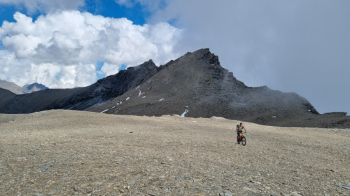
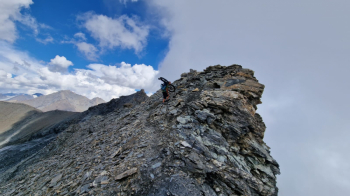
Start from Novalesa 860 m TO, parking and water. Ready to go toxic pedal with paved, cemented, dirt ramps on bold scenic road. Past the very steep cliff the pedal mellows to Grangia Prapiano 1790 m. Nice discreetly pedalable traverse and we join the 2000 Himalyan dirt road with last 100-200 pushings. Some quick up and down for 4-5 km and we find detour to Le Baracon des Chamois. These are the fairly well-maintained remains of an old military that gets pedaled almost entirely to the 2780 m of the Lamet Shelter. Pause merenderos with excellent views of Lake Moncenisio. Continue again with easy Spintage but soon the progression becomes slower in Portage with very steep and tiring sections around 3000 and below the summit col. Landed on the plateau magnificent pedalable plateau and View Point of extreme quality. All that remains is the last 80 m to the summit in slight Portage. 3480 m !
Remnants of Lamet glaciers and unknown peaks to scramble everywhere. Ugly ignorance :-)
Heat clouds keep you from seeing the Motherland but the cousins aren't bad either come on.
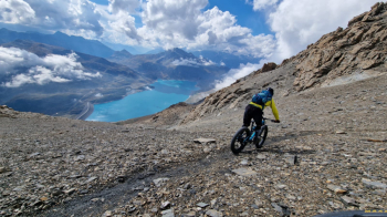
Descent ON: super-photogenic up to the col then first lurk from 50 with easily inconspicuous trail and some balancing act. At 3350 m we abandon the uphill trail that didn't excite us from a descent perspective and veer into the unknown without any information but on sight it doesn't look too bad. The trail is decent but very steep and without grip. If you can manage with gumming you are on your horse or if you are dolomite kamikaze down drizz ! In any case even with caution you have fun and literally surf inside the Lake Moncenisio and its navy blue. Maroo ! Around 2800 the trail disappears and for 200-250 m it is pure survival / discomfort. Sent to kulofan the maps takiamo zö in freeride to the dirt trail below without further discomfort. It is still the des 2000 trail and we ride it entirely trying to stay high where possible. 7-8 km always fast and with various ups and downs.
Arriving just before the Alpe Tour we finally detour to the Sentiero dei Frati. Initially short tratturo then excellent ST. Over 1000 m of beautiful technical descent on very well marked and fun trail. Varies in obstacles, vegetation, speed and effort. Lacks praise only for tall grass in some places that do not make the bottom entirely visible although there are never any particular traps hidden. Very nice. Also the cuts from Grange Fraita 1400 m are always beautiful and pleasant even unexpectedly.
We land directly at the car as beautiful as the sun after 11 hours of solace for the mountains.
In conclusion: definitely non-traditional itinerary, you know what a novelty, but of great interest to all Ciclodisagiati.
Technical Difficulty: Very Difficult
Physical Condition: Very Hard