HOME RANKINGS CHALLENGES ROUTES POI PLANNING SEARCH LOGIN
Italy - Valle d'Aosta, AO
2022/08/06 16:36:18

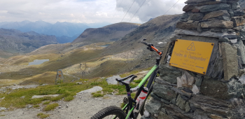
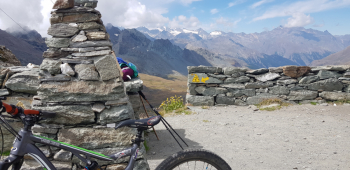
Finestra di Champorcher - sentiero 2 e sentiero 7 b

4 Downloads
0
 
Author
gmzolenart
(104)
Place
Italy - Valle d'Aosta, AO
Km
29,26 km
Elapsed time
06:23:33
Vertical meters
+1 467 mt (1339 - 2750)
Route difficulty
Landscapes
Last update
2023/01/03 17:01:43
Comments
0
Description

The road from the center of Champorcher up to the Dondena Refuge is paved more and more , now almost 6 km out of a total of 10 km; the steep sections to the Miserin Refuge have been partly softened with earth, which undoubtedly favors progression. There are two trails from the Champorcher side up to the Finestra, No. 2 and 7B, the former steeper and starts at Lake Miserin, the latter gentler and is a continuation of the royal road between Lake Nero and Lake Bianco. Trail 2 RESULTS forbidden to mtb in M. Avic Park, I opt for the shoulder portage from the above and then descend from 7B.

The sign from Lake Miserin says 50 minutes to the Finestra and more or less they will be like that even with mtb on the shoulder. The effort is rewarded with beautiful panorama on Cogne and Gran Paradiso side, nice view of lakes on Champorcher side. The descent is rewarding, bc or s2, then mc or s1 on the flat royal road.

Rejoin the uphill mule track and at Dondena cut into the meadow for Ponte delle Maddalene. From here stretch parallel to the gravel road to Creton, turn right and follow the wide path to the Ayasse stream passed with two passages and then slight ascent and nice cobblestones to Chardonnay.

The Hiker Publisher No. 11 - Champorcher Valley - Monte Avic Park Trail map (1:25,000)


Download our free mobile app to send this route to your Garmin device or to navigate it on OSM maps. Android - iOS

Graph

Nearest Routes

2022/08/22
- Italy - Valle d'Aosta, AO
nonnocarb
(266)
30,60 km
Km
+1 265 mt
Vertical meters
Route difficulty
Landscapes
2022/08/22
- Italy - Valle d'Aosta, AO
nonnocarb
(266)
24,52 km
Km
+466 mt
Vertical meters
Route difficulty
Landscapes
2022/09/18
- Italy - Valle d'Aosta, AO
gmzolenart
(104)
18,95 km
Km
+1 050 mt
Vertical meters
Route difficulty
Landscapes
2022/10/11
- Italy - Valle d'Aosta, AO
gmzolenart
(104)
25,12 km
Km
+1 122 mt
Vertical meters
Route difficulty
Landscapes
2023/11/27
- Italy - Valle d'Aosta, AO
33,54 km
Km
+1 450 mt
Vertical meters
Route difficulty
Landscapes
2023/02/05
- Italy - Valle d'Aosta, AO
BAROLO71
(33)
27,80 km
Km
+2 099 mt
Vertical meters
Route difficulty
Landscapes
2022/09/04
- Italy - Valle d'Aosta, AO
gmzolenart
(104)
32,99 km
Km
+1 458 mt
Vertical meters
Route difficulty
Landscapes
2022/09/02
- Italy - Valle d'Aosta, AO
paiogs
(12)
47,61 km
Km
+2 400 mt
Vertical meters
Route difficulty
Landscapes
2023/03/10
- Italy - Valle d'Aosta, AO
gmzolenart
(104)
28,72 km
Km
+1 121 mt
Vertical meters
Route difficulty
Landscapes
45,84 km
Km
+2 206 mt
Vertical meters
Route difficulty
Landscapes

0 Comments