HOME RANKINGS CHALLENGES ROUTES POI PLANNING SEARCH LOGIN
Italy - Piemonte, TO
2022/09/27 21:10:07

Santuario Madonna degli Angeli al Collombardo - bassa Val di Susa

3 Downloads
0
 
Author
gmzolenart
(104)
Place
Italy - Piemonte, TO
Km
23,32 km
Elapsed time
05:15:15
Vertical meters
+970 mt (1368 - 2098)
Route difficulty
Landscapes
Last update
2023/01/03 16:16:16
Comments
0
Description

One of the few flat places was chosen for the start, namely the clearing after the village of Prato del Rio, immediately before the bar that precludes passage in the winter period (April or May, depending on the year). The relatively high starting altitude (about 1400m, when Mocchie stands at 900m) allowed the choice of the final destination at the Shrine of Madonna degli Angeli. The route has no forks except at the Votive Pylon for the Vaccherezza Shrine, simply follow the steep mule track with asphalt interludes, and patiently, you will reach Alpe dei Rat.

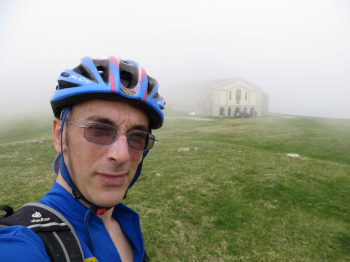
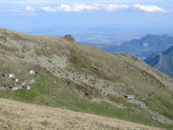
A somewhat moonscape introduces the highest point, a milestone called the Matolda Tomb. A descent to the shrine follows. For the return you follow most of the uphill track, with a detour with a single track partially in the woods that is accessed after passing the Gighè pasture: there is a bar on the left at an altitude of 1636m and, in the direction of Sacra di San Michele, the Giulianera truc with a depression that you pass by deviating to the right and immediately left into the woods. You come out on the main cartroad below Prato del Rio and return to the car.


Download our free mobile app to send this route to your Garmin device or to navigate it on OSM maps. Android - iOS

Graph

Nearest Routes

2022/10/05
- Italy - Piemonte, TO
gmzolenart
(104)
23,24 km
Km
+1 105 mt
Vertical meters
Route difficulty
Landscapes
2022/09/26
- Italy - Piemonte, TO
gmzolenart
(104)
20,27 km
Km
+1 044 mt
Vertical meters
Route difficulty
Landscapes
2023/02/20
- Italy - Piemonte, TO
gmzolenart
(104)
17,05 km
Km
+930 mt
Vertical meters
Route difficulty
Landscapes
2022/11/04
- Italy - Piemonte, TO
gmzolenart
(104)
15,96 km
Km
+718 mt
Vertical meters
Route difficulty
Landscapes
2023/09/09
- Italy - Piemonte, TO
gmzolenart
(104)
23,88 km
Km
+1 150 mt
Vertical meters
Route difficulty
Landscapes
18,22 km
Km
+1 002 mt
Vertical meters
Route difficulty
Landscapes
2022/11/03
- Italy - Piemonte, TO
gmzolenart
(104)
22,02 km
Km
+897 mt
Vertical meters
Route difficulty
Landscapes
2022/11/02
- Italy - Piemonte, TO
gmzolenart
(104)
16,29 km
Km
+751 mt
Vertical meters
Route difficulty
Landscapes
23,40 km
Km
+971 mt
Vertical meters
Route difficulty
Landscapes
28,99 km
Km
+1 193 mt
Vertical meters
Route difficulty
Landscapes

0 Comments