
 Italiano
 Deutsch
2022/08/06 21:29:54
Rifugio Gran Tournalin - giro antiorario
Author

Place
Italy - Valle d'Aosta, AO
Km
16,23 km
Elapsed time
04:31:04
Vertical meters
+931 mt (1621 - 2544)
Route difficulty
Landscapes
Last update
2023/01/03 17:01:05
Comments
Description
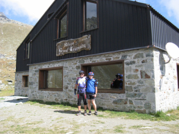
Start in Saint Jacques and proceed west on a dirt road through the hamlets of Nana Dessous and Nana Dessus, then the slope becomes steep and proceed north to the G. Tournalin Refuge, open from late June to mid-September.
The descent variant involves a cut just below the Refuge following trail 4 and 4a, crossing the Nana Creek. We rejoin the dirt road at Nana Inferiore and resume trail 4 at Croues, thus returning to St. Jacques.
Map L'Escursionista No. 8 Alte valli d'Ayas e del Lys Scale 1:25,000
Graph
Nearest Routes
19,73 km
Km
+1 385 mt
Vertical meters
Route difficulty
Landscapes
19,82 km
Km
+989 mt
Vertical meters
Route difficulty
Landscapes
2023/08/27
- Italy - Valle d'Aosta, AO 32,17 km
Km
+1 969 mt
Vertical meters
Route difficulty
Landscapes
2022/10/18
- Italy - Valle d'Aosta, AO 31,51 km
Km
+2 400 mt
Vertical meters
Route difficulty
Landscapes
22,09 km
Km
+1 233 mt
Vertical meters
Route difficulty
Landscapes
18,02 km
Km
+1 780 mt
Vertical meters
Route difficulty
Landscapes
26,22 km
Km
+950 mt
Vertical meters
Route difficulty
Landscapes
32,97 km
Km
+1 613 mt
Vertical meters
Route difficulty
Landscapes