Italiano
 Deutsch
Corno Bussola 3023 m - Punta Palasina 2778 m - Punta Valnera 2754 m

Cycloalpine route, exposure and technicality. Finale hyper, FBL.
We return after a few years to the Compass Horn for an autumn classic but with still some nice new trails to map. See also: Corno Bussola 3022 m Corno Bussola 3022 m - Colle Bringuez 2661 m
Start from Brusson 1360 m, convenient parking but no water. A few meters of asphalt and it is immediately carpeted. Known and beautiful climb as here Palasinaz 2500 Winter Edition then from lakes Battaglia-Pocia-Long elegant and panoramic Portage to the top (an easy hardware store). Immortal 360 superpanorama. 3023 m. TOP
Descent ON: first little piece always impetuous then simply the best ridge in VdA. The Leysser's is barefoot Ursuline nuns in comparison. Landing at Palasina pass 2668 m between steeps, switchbacks and exposed flow. Very nice but beware of ending too soon at Mascognaz.
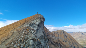
Soft portage, pedal and push and the Palasina peak arrives immediately 2778 m. Encore panorama and sandwich.
The next col is a bit precious because to get there after the little descent from the peak you have to pass a few delicate meters and also lose a thread of altitude. The Corno Vitello was on the agenda but will have to wait because while only missing a couple of cents the autumn days are no longer long enough for various extensions. Well, zö de lè toward the Valfredda lakes.
Gorgeous and secluded valley but also nice uncomfortable initially. Trail in fact very single and hairpin turns very narrow and technical. The ones on the right put me on the edge. The next traverse and the arrival at the lower lake then keep nice and crisp. I arrive at the Arp hut after last crag easier but still nice alpine. Trim change.
Portage and push and regain another 200 m to the overhanging jump bypassing Punta Valfredda and entering the plateau below Valnera. Remnants of a mule track facilitate arrival at the eponymous col not to be confused with the broader col that accesses the Lys valley on the other side and which we had visited here Colle di Valnera. The Point is patently inconvenient but should be sanctified by captatio benevolentiae to the Cyclolean gods. Only 74 m but the tris panorama from the 2754 m summit with almost golden hour and autumn mists in the valley floor is Top. Maroo what a beauty!
Zö now daii zu zu. Out of 74 m you do maybe 3 in the saddle but those are details. From the collar then the trail is in the first 100-150 m rutted and shabby (although in places it shows signs of a more glorious past) so there is little or no riding. Just below, however, it becomes rustic but cyclable. You get around Lake Chamen well and with little incline also pass Estoul Lake 2450 m. Another lonely and wonderful valley. On the left the Eclou vent already visited from the Lys side. Cliffs and slight descent work the flanks but soon you begin to descend more firmly and without more special effort with the path widening and simplifying as you go. Emerging on one of the many forestry trails in the area we climb back up to beyond the lift line and take a mini DH tracked with no luck a few years ago. Fast but in a beautiful larch forest and still the only alternative on trail. From Estoul it is a known fact. Transfer to Chamousira mines 1750 m and scrabble on one of the most incredible trails in VdA. Steep, exposed, perfect bottom and shoveling tight switchbacks. Up toxic then gradually more potable. Recommended mid-frame joint for easier maneuvering. Landed in Brusson 5 min climb and we are at the car.
Bottom line: super October classic with all the ingredients for a great day of Cyclo-mountaineering.