HOME RANKINGS CHALLENGES ROUTES POI PLANNING SEARCH LOGIN
Italy - Trentino-Alto Adige/Südtirol, BZ
2022/10/22 17:59:52

Schlern Tour

64 Downloads
3
 
Author
nonnocarb
(266)
Place
Italy - Trentino-Alto Adige/Südtirol, BZ
Km
39,26 km
Elapsed time
05:48:54
Vertical meters
+1 886 mt (944 - 2558)
Route difficulty
Landscapes
Last update
2022/10/22 19:15:36
Comments
0
Description

A fantastic route in the heart of the Dolomites, with fun trails and breathtaking views. Be careful, the trail from the Tiers alpine hut onward is off-limits to bikes, but if you pass in October no one will say anything.

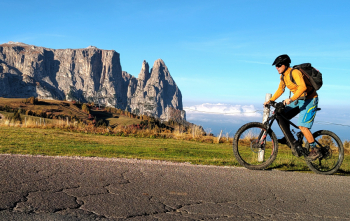
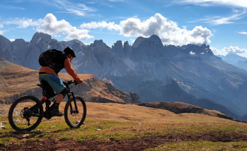
From the parking lot of the Siusi gondola lift up to Compaccio, the road after 9 a.m. is closed to traffic except for residents. Alternatively you can go up with the cable car. When we get to Compaccio we go up to the Molignon hut and we can admire the whole of the Seiser Alm with Sasso Piatto, Sasso Lungo and the Sciliar, as well as the Val Gardena Dolomites. From Molignon we descend slightly and then climb hard to the Alpe di Tires hut, with fantastic views of the Denti di Terrarossa.

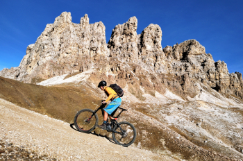
Now a nice fast trail downhill and you get to the trickiest point, the ascent to the Tiers Alp.

It is not long, about half an hour with 10 minutes on the bike and 20 minutes pushing. With the ebike you can also do some pedaled sections.

Finally we are at the highest point, with beautiful views of alps and dolomites. From here a nice trail, technical in places, takes us to the Bolzano hut.

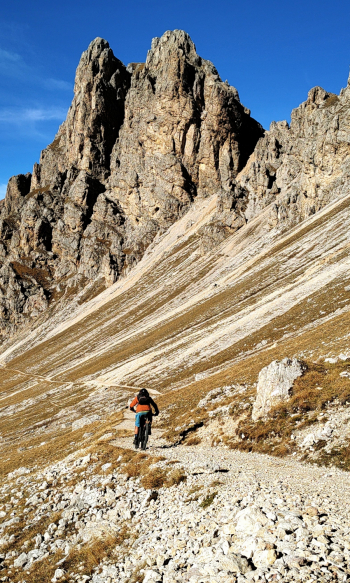
Now the most fun part begins, provided you have good downhill technique. The Prugelweg trail, which passes through a narrow canyon, is made of wooden footbridges, large uneven boulders and many steps with loose stones.

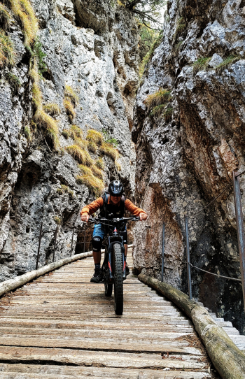
Therefore, be careful not to cross it after heavy rain, because the wet wood would be very slippery and dangerous! The descent continues, very long, to the beautiful Tires Lakes. Here you take a false-flat trail, very fun with technical sections, to the parking lot.

Download our free mobile app to send this route to your Garmin device or to navigate it on OSM maps. Android - iOS

Graph

Nearest Routes

2023/03/04
- Italy - Trentino-Alto Adige/Südtirol, BZ
nonnocarb
(266)
50,79 km
Km
+1 800 mt
Vertical meters
Route difficulty
Landscapes
2023/02/26
- Italy - Trentino-Alto Adige/Südtirol, BZ
nonnocarb
(266)
38,20 km
Km
+1 601 mt
Vertical meters
Route difficulty
Landscapes
2023/02/26
- Italy - Trentino-Alto Adige/Südtirol, BZ
nonnocarb
(266)
36,49 km
Km
+1 550 mt
Vertical meters
Route difficulty
Landscapes
2023/03/07
- Italy - Trentino-Alto Adige/Südtirol, BZ
nonnocarb
(266)
36,18 km
Km
+1 590 mt
Vertical meters
Route difficulty
Landscapes
2022/09/19
- Italy - Trentino-Alto Adige/Südtirol, BZ
37,99 km
Km
+1 851 mt
Vertical meters
Route difficulty
Landscapes
2023/02/26
- Italy - Trentino-Alto Adige/Südtirol, BZ
nonnocarb
(266)
39,56 km
Km
+1 700 mt
Vertical meters
Route difficulty
Landscapes
2023/03/06
- Italy - Trentino-Alto Adige/Südtirol, BZ
nonnocarb
(266)
70,00 km
Km
+2 200 mt
Vertical meters
Route difficulty
Landscapes
2022/08/03
- Italy - Trentino-Alto Adige/Südtirol, BZ
steve-U
(21)
26,36 km
Km
+1 245 mt
Vertical meters
Route difficulty
Landscapes
2023/03/07
- Italy - Trentino-Alto Adige/Südtirol, BZ
nonnocarb
(266)
52,68 km
Km
+1 700 mt
Vertical meters
Route difficulty
Landscapes
2023/02/26
- Italy - Trentino-Alto Adige/Südtirol, BZ
nonnocarb
(266)
21,93 km
Km
+1 002 mt
Vertical meters
Route difficulty
Landscapes

0 Comments