HOME RANKINGS CHALLENGES ROUTES POI PLANNING SEARCH LOGIN
Italy - Trentino-Alto Adige/Südtirol, BZ
2022/10/26 15:17:24

Forcella di Covelano

24 Downloads
0
 
Author
nonnocarb
(266)
Place
Italy - Trentino-Alto Adige/Südtirol, BZ
Km
32,13 km
Elapsed time
04:58:38
Vertical meters
+2 033 mt (706 - 2443)
Route difficulty
Landscapes
Last update
2023/01/03 15:58:29
Comments
0
Description

The Covelano Fork in the Venosta Valley is a classic and spectacular route, lately ridden every year by hundreds of bikers, which I first discovered many years ago together with my friend Roberto.

We usually ride it in late spring, as the excellent sun exposure melts the snow up to 2500 meters above sea level.

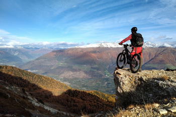
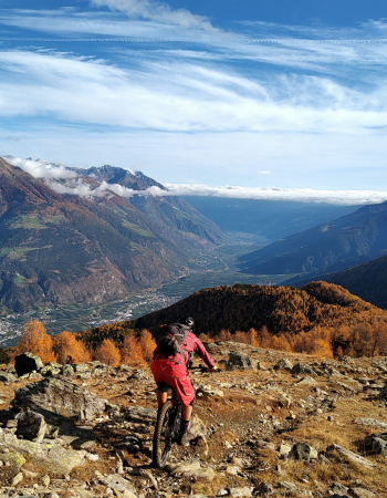
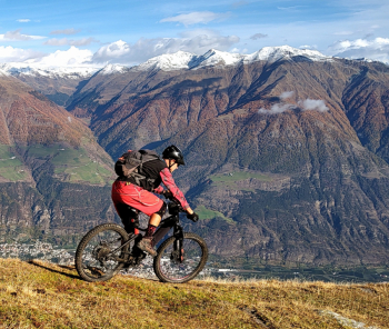
This year for the first time I am climbing to the fork in autumn and by ebike, and the choice was great, both because of the magnificent autumn colors and because by ebike you can reach the fork without putting your bike on your back, but pedaling down the steep meadows. This way you are able to face the descent, one of the longest, most technical, fun and challenging in South Tyrol, over 1700 meters of elevation gain, more refreshed and rested! The views are magnificent!

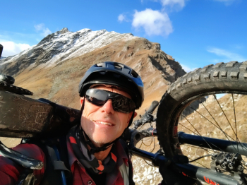
You have to put your bike on your back anyway afterwards, for a few minutes on the short steel-rope trail to reach the highest point of the tour!

At the end of the first descent there is a long traverse with uphill sections to connect to the next trail. In the end, you can also avoid it if you are tired, but the flat trail along the gully and the final beautiful descent from the obermontani castle is worth the effort.

Itinerary for experts and well trained.


Download our free mobile app to send this route to your Garmin device or to navigate it on OSM maps. Android - iOS

Graph

Nearest Routes

2022/10/30
- Italy - Trentino-Alto Adige/Südtirol, BZ
nonnocarb
(266)
72,93 km
Km
+2 970 mt
Vertical meters
Route difficulty
Landscapes
27,47 km
Km
+1 500 mt
Vertical meters
Route difficulty
Landscapes
28,35 km
Km
+1 500 mt
Vertical meters
Route difficulty
Landscapes
2023/03/07
- Italy - Trentino-Alto Adige/Südtirol, BZ
nonnocarb
(266)
37,04 km
Km
+1 770 mt
Vertical meters
Route difficulty
Landscapes
2023/03/04
- Italy - Trentino-Alto Adige/Südtirol, BZ
nonnocarb
(266)
26,12 km
Km
+1 250 mt
Vertical meters
Route difficulty
Landscapes
2023/06/01
- Italy - Trentino-Alto Adige/Südtirol, BZ
Robibz
(19)
31,15 km
Km
+1 173 mt
Vertical meters
Route difficulty
Landscapes
2023/03/07
- Italy - Trentino-Alto Adige/Südtirol, BZ
nonnocarb
(266)
51,34 km
Km
+980 mt
Vertical meters
Route difficulty
Landscapes
2023/03/04
- Italy - Trentino-Alto Adige/Südtirol, BZ
nonnocarb
(266)
45,04 km
Km
+1 520 mt
Vertical meters
Route difficulty
Landscapes
2022/08/22
- Italy - Trentino-Alto Adige/Südtirol, BZ
nonnocarb
(266)
30,40 km
Km
+1 865 mt
Vertical meters
Route difficulty
Landscapes
2023/03/04
- Italy - Trentino-Alto Adige/Südtirol, BZ
nonnocarb
(266)
28,35 km
Km
+1 500 mt
Vertical meters
Route difficulty
Landscapes

0 Comments