HOME RANKINGS CHALLENGES ROUTES POI PLANNING SEARCH LOGIN
Italy - Trentino-Alto Adige/Südtirol, BZ
2022/10/30 09:13:47

Passo Gelato

75 Downloads
3
 
Author
nonnocarb
(266)
Place
Italy - Trentino-Alto Adige/Südtirol, BZ
Km
86,32 km
Elapsed time
09:24:00
Vertical meters
+2 856 mt (306 - 2888)
Route difficulty
Landscapes
Last update
2023/01/03 15:56:12
Comments
0
Description

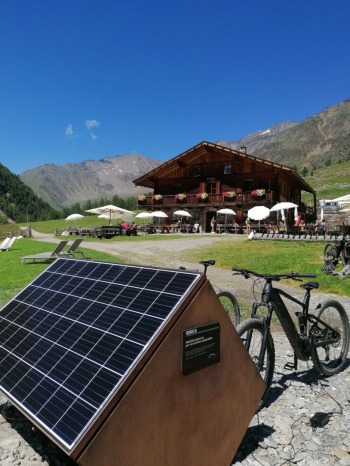
The Gelato Pass is located at an altitude of 2874 meters between the Fosse and Passeier valleys. It is reached via an old military trail, which is completely rideable and well maintained. Just below the pass stands the Petrarca hut, destroyed a few years ago by an avalanche and now rebuilt. Before starting the most beautiful section, at an altitude of 2050, is the Gelato farmstead, with excellent refreshments and ebike recharge, an ideal stop before tackling the last climb.


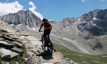
The descent is very long and very enjoyable, always on a military trail, with some rather challenging sections.

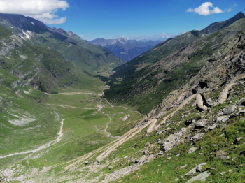
The scenery is really beautiful, exciting and wild, climbing among other rocky peaks in white, red and black, contrasting with the green of the meadows and the blue of the sky.

The full tour must be done clockwise and is quite challenging. At the beginning of the Schnalstal valley there are two long tunnels that are rather troublesome; possibly you can pass on the old road to the left, although it is forbidden.

Best done on stable, warm days, as at the Gelato Pass the weather can change very quickly.

Download our free mobile app to send this route to your Garmin device or to navigate it on OSM maps. Android - iOS

Graph

Nearest Routes

2023/02/26
- Italy - Trentino-Alto Adige/Südtirol, BZ
nonnocarb
(266)
36,78 km
Km
+1 610 mt
Vertical meters
Route difficulty
Landscapes
2023/03/05
- Italy - Trentino-Alto Adige/Südtirol, BZ
nonnocarb
(266)
64,24 km
Km
+2 500 mt
Vertical meters
Route difficulty
Landscapes
2023/03/01
- Italy - Trentino-Alto Adige/Südtirol, BZ
nonnocarb
(266)
49,83 km
Km
+950 mt
Vertical meters
Route difficulty
Landscapes
2022/11/04
- Italy - Trentino-Alto Adige/Südtirol, BZ
nonnocarb
(266)
32,17 km
Km
+1 852 mt
Vertical meters
Route difficulty
Landscapes
2023/03/06
- Italy - Trentino-Alto Adige/Südtirol, BZ
nonnocarb
(266)
32,34 km
Km
+1 500 mt
Vertical meters
Route difficulty
Landscapes
2023/03/01
- Italy - Trentino-Alto Adige/Südtirol, BZ
nonnocarb
(266)
86,66 km
Km
0 mt
Vertical meters
Route difficulty
Landscapes
2023/03/04
- Italy - Trentino-Alto Adige/Südtirol, BZ
nonnocarb
(266)
71,35 km
Km
+1 830 mt
Vertical meters
Route difficulty
Landscapes
2023/03/04
- Italy - Trentino-Alto Adige/Südtirol, BZ
nonnocarb
(266)
58,50 km
Km
+1 370 mt
Vertical meters
Route difficulty
Landscapes
2023/03/05
- Italy - Trentino-Alto Adige/Südtirol, BZ
nonnocarb
(266)
85,71 km
Km
+2 730 mt
Vertical meters
Route difficulty
Landscapes
2023/03/01
- Italy - Trentino-Alto Adige/Südtirol, BZ
nonnocarb
(266)
43,62 km
Km
+1 615 mt
Vertical meters
Route difficulty
Landscapes

0 Comments