HOME RANKINGS CHALLENGES ROUTES POI PLANNING SEARCH LOGIN
Italy - Trentino-Alto Adige/Südtirol, BZ
2022/11/01 09:24:46

Kuhleiten

4 Downloads
0
 
Author
nonnocarb
(266)
Place
Italy - Trentino-Alto Adige/Südtirol, BZ
Km
42,55 km
Elapsed time
05:31:31
Vertical meters
+2 157 mt (314 - 2345)
Route difficulty
Landscapes
Last update
2022/11/01 09:26:54
Comments
0
Description

Very challenging and tiring route, designed to be able to get to Merano 2000 without asphalt. In order to be able to do it, you have to walk some very steep trails that are normally done downhill. It is therefore designed to be done by e-mtb, those who want to do it by regular mtb will have to push the bike a lot.

From Merano go up on path 2 to Greiter. From here it is still a very steep climb to the little church of Santa Caterina. Then take the forest road to the Maia hut and then on the European path to the Merano hut.

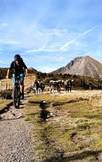
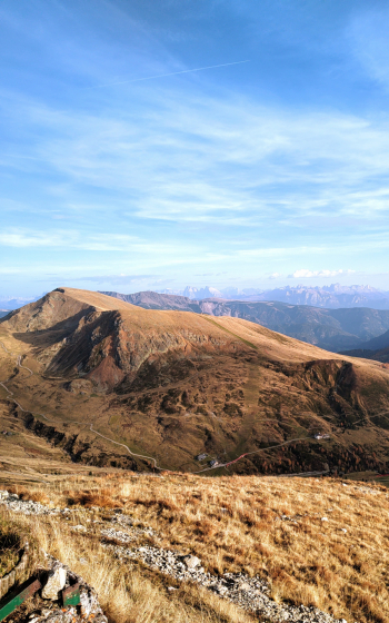
From here last steep climb to the Kuhleiten hut, with magnificent views of the Dolomites and surrounding mountains.

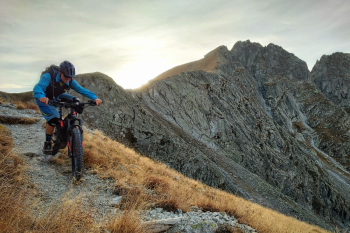
You descend on trail 19, which is very challenging and bumpy at first, but soon after was recently redone, and descend on smooth terrain in beautiful surroundings to the Steriwalder hut (refreshment).

From here take the path to Taser (possibly not in high season because it is very busy, alternatively descend on the forest road) and then the path to Verdines and Scena.

Download our free mobile app to send this route to your Garmin device or to navigate it on OSM maps. Android - iOS

Graph

Nearest Routes

2023/03/01
- Italy - Trentino-Alto Adige/Südtirol, BZ
nonnocarb
(266)
53,70 km
Km
+1 570 mt
Vertical meters
Route difficulty
Landscapes
2023/03/05
- Italy - Trentino-Alto Adige/Südtirol, BZ
nonnocarb
(266)
85,71 km
Km
+2 730 mt
Vertical meters
Route difficulty
Landscapes
2022/11/21
- Italy - Trentino-Alto Adige/Südtirol, BZ
nonnocarb
(266)
41,95 km
Km
+1 783 mt
Vertical meters
Route difficulty
Landscapes
2022/10/22
- Italy - Trentino-Alto Adige/Südtirol, BZ
nonnocarb
(266)
65,78 km
Km
+2 336 mt
Vertical meters
Route difficulty
Landscapes
2023/03/01
- Italy - Trentino-Alto Adige/Südtirol, BZ
nonnocarb
(266)
76,06 km
Km
+2 300 mt
Vertical meters
Route difficulty
Landscapes
2023/03/01
- Italy - Trentino-Alto Adige/Südtirol, BZ
nonnocarb
(266)
61,03 km
Km
+2 156 mt
Vertical meters
Route difficulty
Landscapes
2023/03/04
- Italy - Trentino-Alto Adige/Südtirol, BZ
nonnocarb
(266)
58,50 km
Km
+1 370 mt
Vertical meters
Route difficulty
Landscapes
2023/03/07
- Italy - Trentino-Alto Adige/Südtirol, BZ
nonnocarb
(266)
33,38 km
Km
+1 600 mt
Vertical meters
Route difficulty
Landscapes
2023/03/05
- Italy - Trentino-Alto Adige/Südtirol, BZ
nonnocarb
(266)
31,25 km
Km
+1 100 mt
Vertical meters
Route difficulty
Landscapes
2023/03/05
- Italy - Trentino-Alto Adige/Südtirol, BZ
nonnocarb
(266)
93,54 km
Km
+2 520 mt
Vertical meters
Route difficulty
Landscapes

0 Comments