Italiano
 Deutsch
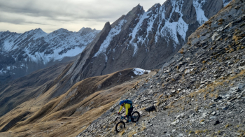
Col des Ceingles 2809 m

Not too challenging cycle mountaineering route ideal for the end of October after GSB closure.
Once again this year, don't let us miss the chance for a nice loop hike in the Great St. Bernard Valley after the pass closes for Winter and finally goes silent.
Start from Saint Rhémy 1600 m parking facilities giant and deserted. No water. Deserted little road to Couchpache and then excellent forestry/slightly uphill trail to state highway. As an alternative to the excellent orographic off road sx we pull straight up to the tunnel. A trivial technical problem resets me to 10 speed and so in single speed I trudge up to 2300 m but fortunately on bituminous but slight inclines. The program was more fierce but the ungainly start advised prudently to shorten and so we deviate directly on excellent trail to the Col de Saint Remy between pushes, pedaling and nice little descent to Praz de Farcoz just below our friend Fourchon. Soft portage of 300 m and we are at the beautiful two-faced pass altitude 2540 m where there is a magnificent view of the wild Comba des Thoules. Beautiful mountains and "belts" everywhere but the slide of the Gran Golliat 3200 m attracts like a magnet. In the distance the day's destination in full N and well snow-covered impensers but the approach trail is very good with some 'unexpected great pedal just below the pass. The switchbacks toward 2700 deserve honorable mention and would be cool on the descent as well. Last few meters very steep but with not too deep snow so ordinance discomfort. Col des Ceingles 2809 m! Almost summer-like warmth, spacey panorama and no bipeds in sight.
Descent ON: despite the bizarre name the Comba des Merdeux immediately greets us with textbook switchbacks with excellent grip and good difficulty, as always, those on the right. The trail after a short traverse plummets to the valley but well marked and maintained. Alpine lushness of excellence with plenty of hairpin turns even on scenic ridge. At 2500 you veer sharply and with all ease traverse to Rifugio Frassati to join AV1. I had never done it downhill but it proves to be beautiful and fun. Still perfectly cyclable with just enough effort and multitrack just above Tza Merdeux 2250 m. A few easy meadows, a small piece of farm track and then more single track to the creek des Thoules. Very nice. From the creek super balcony among the most scenic low altitude AV which with golden hour bonus is worth double. Marooo ! From Alpe Merdeux Inferiore grand finale. 300 m still perfect and fun on fast and playful ST. We land directly at the car.
In conclusion: not extreme itinerary but particularly beautiful and super recommended, as said, at the end of October.