
 Italiano
 Deutsch
M. Ravinet and S.Pietro dei Monti

M. Ravinet little-known peak that rises on the ridge of M Carmo and can 'be included in the descent from Carmo to Toirano.
This itinerary allows you to concatenate the summit of Ravinet with the fantastic abbey of San Pietro dei Monti, an idyllic place with breathtaking views, which offers one of the most beautiful and difficult descents of western Liguria, very free-range all on fixed rock and at times with gravel !
Departure from Toirano and take the state road up to Giogo di Toarano, at the hairpin bend below the pass, leave the asphalt road and continue straight on a dirt road, after 400 meters follow a secondary dirt road on the left that, with some Christian-killing ramps, will allow you to gain altitude until it joins a path that, slightly uphill and with a very beautiful route, will take you to the meadows of Ciazzalunga on the ridge that descends from M. Carmo.
From here begins the very nice descent that joins the path x red and arrives at the saddle of Cà du Fò. Here the trail widens and makes a series of very beautiful and technical ups and downs until it reaches below Ravinet. Continuing on the x red you can descend much faster to San Pietrono, we instead aim for the summit that is reached in a short portage of 100 mt D+ by trail tracks.
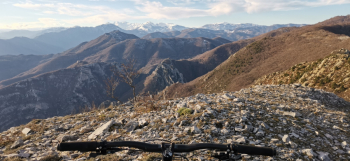
From the summit beautiful view also of the upper Tanaro Valley,
We descend with a not very evident path (follow the tracks) keeping to the right and following a few scattered cairns until we reach a clearing overlooking the sea, from there we follow on the right always not very evident tracks first in the woods, then on rocky clearings until we arrive on the path coming from Giogo di Toirano.
A short climb leads us to the abbey of San Pietro nei Monti where a stop is a must.
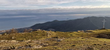
Contemplating the landscape we descend on the meadow in front of the church from which the aerial path starts on the left. The descent is spectacular, all on fixed rock that is never trivial, with several challenging hairpin bends , then we make a traverse through the woods that gives a little respite but always very beautiful until we arrive on some meadows from which the almost level path to San Pietrino starts.
After 100 m we leave the main path to take one on the right that descends to Dari , here it starts at first on a fixed slab rock bottom, then gradually getting more and more pissed off with several moving stones that force a very careful ride seasoned by some very peppery hairpin bends that leave no respite and that earn us a well-deserved beer in Toirano.