HOME RANKINGS CHALLENGES ROUTES POI PLANNING SEARCH LOGIN
Italy - Emilia-Romagna, PR
2022/11/22 21:11:35

Mount Zatta

6 Downloads
1
 
Author
P.Fizz
(5)
Place
Italy - Emilia-Romagna, PR
Km
21,79 km
Elapsed time
04:18:01
Vertical meters
+978 mt (718 - 1366)
Route difficulty
Landscapes
Last update
2022/11/24 19:10:46
Comments
0
Description


Start from Santa Maria del Taro where, at the beginning of the village, there is a small parking lot and you can find a fountain in front of the church.

We immediately climb on asphalt, then dirt road to the Griffi pass, more asphalt downhill to the Bocco pass, continue to the Bocco pond.

On the right begins the Zatta forest road, which we will leave almost immediately to take the path that will take us to the summit. The first part is steep and there is some pushing/carrying of the bike for a short distance; then it becomes all cyclable, with good leg.

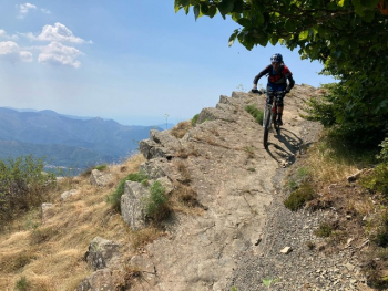
The trail is beautiful and meanders through the woods to Zatta di Ponente.

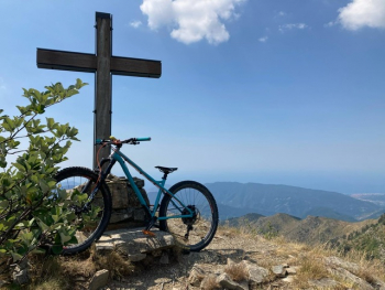
The panoramic peak overlooks the Graveglia Valley.

The ridge from Ponente to Levante is all up and down, sometimes exposed, which also requires a bit of "pushge" ; having reached the summit, of Zatta di Levante the descent begins, beautiful enjoyable, flowing with technical stretches, especially on the final part.

Reaching the asphalt, we go up again until we meet on the right a forest road that briefly becomes a path, One last bumpy tear and we enter the woods that with a traverse leads us to take the last descent: dirty, neglected and fun for lovers of the genre.

At the bottom we cross the village and reach the car....

Download our free mobile app to send this route to your Garmin device or to navigate it on OSM maps. Android - iOS

Graph

Nearest Routes

2022/11/23
- Italy - Emilia-Romagna, PR
P.Fizz
(5)
31,63 km
Km
+1 250 mt
Vertical meters
Route difficulty
Landscapes
2022/11/24
- Italy - Liguria, GE
P.Fizz
(5)
29,07 km
Km
+1 202 mt
Vertical meters
Route difficulty
Landscapes
2023/04/30
- Italy - Liguria, GE
miciolo
(27)
33,40 km
Km
+1 317 mt
Vertical meters
Route difficulty
Landscapes
29,52 km
Km
+1 186 mt
Vertical meters
Route difficulty
Landscapes
2023/03/04
- Italy - Liguria, GE
Antosangui
(105)
12,81 km
Km
+298 mt
Vertical meters
Route difficulty
Landscapes
2023/03/07
- Italy - Liguria, GE
Antosangui
(105)
13,73 km
Km
+502 mt
Vertical meters
Route difficulty
Landscapes
2023/03/08
- Italy - Liguria, GE
Antosangui
(105)
13,62 km
Km
+641 mt
Vertical meters
Route difficulty
Landscapes
2023/03/05
- Italy - Liguria
Antosangui
(105)
55,60 km
Km
+1 450 mt
Vertical meters
Route difficulty
Landscapes
2023/03/07
- Italy - Liguria, GE
Antosangui
(105)
33,08 km
Km
+1 285 mt
Vertical meters
Route difficulty
Landscapes
2023/03/03
- Italy - Liguria, GE
Antosangui
(105)
14,37 km
Km
+533 mt
Vertical meters
Route difficulty
Landscapes

0 Comments