
 Italiano
 Deutsch
2022/08/22 14:01:34
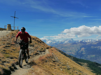
Pila cima Covis
Author

Place
Italy - Valle d'Aosta, AO
Km
17,77 km
Elapsed time
06:58:06
Vertical meters
+1 079 mt (1754 - 2694)
Route difficulty
Landscapes
Last update
2023/01/03 16:53:09
Comments
Description
Very challenging route, both for the steep, rocky climb to the Covis summit, ideal for ebikes, and for the descent on the Pila bikepark black trail. Stunning views, to say the least, with views of virtually all the mountains of the Aosta Valley. Departure from the Chamolè chairlift parking lot.
Graph
Nearest Routes
37,61 km
Km
+800 mt
Vertical meters
Route difficulty
Landscapes
31,30 km
Km
+2 574 mt
Vertical meters
Route difficulty
Landscapes
2022/10/24
- Italy - Valle d'Aosta, AO 69,26 km
Km
+1 967 mt
Vertical meters
Route difficulty
Landscapes
29,77 km
Km
+1 356 mt
Vertical meters
Route difficulty
Landscapes
2022/10/03
- Italy - Valle d'Aosta, AO 18,80 km
Km
+1 062 mt
Vertical meters
Route difficulty
Landscapes
23,17 km
Km
+1 015 mt
Vertical meters
Route difficulty
Landscapes
2022/10/04
- Italy - Valle d'Aosta, AO 23,03 km
Km
+1 249 mt
Vertical meters
Route difficulty
Landscapes
52,17 km
Km
+3 400 mt
Vertical meters
Route difficulty
Landscapes
30,79 km
Km
+1 471 mt
Vertical meters
Route difficulty
Landscapes
24,43 km
Km
+1 450 mt
Vertical meters
Route difficulty
Landscapes