HOME RANKINGS CHALLENGES ROUTES POI PLANNING SEARCH LOGIN
Italy - Trentino-Alto Adige/Südtirol, BZ
2022/08/22 21:21:29

Forcella di Sopranes

8 Downloads
3
 
Author
nonnocarb
(266)
Place
Italy - Trentino-Alto Adige/Südtirol, BZ
Km
61,08 km
Elapsed time
08:36:35
Vertical meters
+2 334 mt (316 - 2577)
Route difficulty
Landscapes
Last update
2023/01/03 16:52:04
Comments
7
Description

Trail of the Dead, Sopranes Fork, lakes and endless descent on Merano!

A rather long and tiring ride, 65km and 2400+, that I had done a couple of times before with almost two hours of portage. I didn't think I could do it on an ebike, but instead I managed to do it all without ever putting the bike shoulder down, for the most part pedaling and a little pushing, without too much difficulty, along a trail whose name puts some apprehension of the dead.

Why is it called that? From the earliest times the community of Plan, in the upper Passeiertal valley, has depended on the parish of St. Peter of Quarazze, a hamlet of Merano.

A mountain path, called the Path of the Dead, connects the two localities over the Sopranes Pass, 2600m. It is the path used, until the 18th century, to transport the dead from Plan to Quarazze. The bodies, made to freeze during the winter, are brought to St. Peter's parish in the spring for burial. At the same time, women lead newborn babies with them, to be baptized in the church.

Today of course the trail is used by hikers and some bikers.

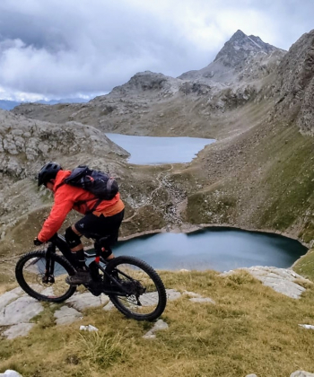
We said very long ascent, 5 hours from Merano, but arrived at the 2600 of the pass opens an enchanting scenery on the of 10 Sopranes lakes, set on the high mountains that shelter Merano from the north winds.

And especially starts a never-ending 2300-meter descent, challenging, technical and fun, all the way back home.

Wonder.


Download our free mobile app to send this route to your Garmin device or to navigate it on OSM maps. Android - iOS

Graph

Nearest Routes

2022/10/28
- Italy - Trentino-Alto Adige/Südtirol, BZ
nonnocarb
(266)
61,08 km
Km
+2 334 mt
Vertical meters
Route difficulty
Landscapes
2023/03/02
- Italy - Trentino-Alto Adige/Südtirol, BZ
nonnocarb
(266)
51,00 km
Km
+1 610 mt
Vertical meters
Route difficulty
Landscapes
2023/03/05
- Italy - Trentino-Alto Adige/Südtirol, BZ
nonnocarb
(266)
31,25 km
Km
+1 100 mt
Vertical meters
Route difficulty
Landscapes
2023/03/05
- Italy - Trentino-Alto Adige/Südtirol, BZ
nonnocarb
(266)
36,69 km
Km
+1 310 mt
Vertical meters
Route difficulty
Landscapes
2023/03/01
- Italy - Trentino-Alto Adige/Südtirol, BZ
nonnocarb
(266)
76,06 km
Km
+2 300 mt
Vertical meters
Route difficulty
Landscapes
2022/10/22
- Italy - Trentino-Alto Adige/Südtirol, BZ
nonnocarb
(266)
65,78 km
Km
+2 336 mt
Vertical meters
Route difficulty
Landscapes
2022/11/21
- Italy - Trentino-Alto Adige/Südtirol, BZ
nonnocarb
(266)
41,95 km
Km
+1 783 mt
Vertical meters
Route difficulty
Landscapes
2023/03/05
- Italy - Trentino-Alto Adige/Südtirol, BZ
nonnocarb
(266)
93,54 km
Km
+2 520 mt
Vertical meters
Route difficulty
Landscapes
2023/03/07
- Italy - Trentino-Alto Adige/Südtirol, BZ
nonnocarb
(266)
33,38 km
Km
+1 600 mt
Vertical meters
Route difficulty
Landscapes
2023/03/07
- Italy - Trentino-Alto Adige/Südtirol, BZ
nonnocarb
(266)
48,57 km
Km
+1 550 mt
Vertical meters
Route difficulty
Landscapes

7 Comments