
 Italiano
 Deutsch
Fürhörnli

Beautiful tour starting in the center of Chur.
You leave the capital of Graubünden by following the road to Arosa. The first 6 kilometers are quite busy, and have a fair amount of incline, which, combined with the fact that the whole ride faces south, will make you sweat for good.
Before turning left onto the road closed to cars remember to fill up with water, because this is the last fountain you will find on the climb.
A climb that, after a piece with gentle inclines, gets steeper and steeper. You may wonder who is the donkey who built such a steep road, especially in its final part, and you will find the answer in the last house you will see before taking the spectacular trail to the ridge.
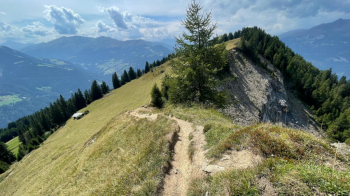
Here watch out, because to the right the precipice awaits you, while to the left is a nice grassy area that you can use to push your bike if you are afraid of exposure.

I definitely recommend you go to the Fürhörnli on foot, before starting the descent, because the view is fantastic: we are 1300 meters above Chur with beautiful views of the Rhine valley and surrounding mountains( videohere )

The descent has it all: first a smooth but fairly steep section on the meadows, then a rooty section in the forest, with some steep and counter-sloping parts, then more or less technical switchbacks. And that's all the way down into town. Make sure your brakes are working well, and in wet weather, I hope your riding technique is good.
I rode this route in the summer when it was all dry.
You arrive in downtown Chur, the trail leads to the start of the cable car to Brambrüesch, where there is free parking.